
Say you have one free morning in Seoul. You want to feel the city, not photograph it from a bus window. Inwangsan is one of the most rewarding walks in town. Few hikes compress the whole story of Seoul into roughly two hours. Here you get a Joseon fortress wall underfoot and royal palace rooftops below. N Seoul Tower glows on the far ridge. The climb is over granite rather than through a tourist queue, and it starts and ends within reach of the subway.
This is not a wilderness epic, and it does not pretend to be. It is a 338-meter granite hill in the middle of a megacity — and that is precisely its appeal. It delivers the most quintessentially Seoul view in the city for free. And it barely asks you to leave the subway map to reach it.
- Location: Inwangsan (인왕산), spanning Jongno-gu and Seodaemun-gu, central Seoul, just west of Gyeongbokgung Palace. It’s a public mountain park with no single street address.
- Hours: Open 24 hours, day and night. The upper granite has no lighting, so plan night hikes carefully.
- Price: Free. No permit, no ID required (2026).
- Getting there: Subway Line 3. Dongnimmun Station (Exits 1–2) is the main City Wall trailhead; Gyeongbokgung Station (Exit 1) puts you near the Sajik Park side in 10–15 minutes.
- ⏱ Time needed: About 2 hours round trip for the ridge-and-summit loop; a relaxed half-day with shrine and viewpoint stops.
- 🔗 Pair it with: Gyeongbokgung Palace (15-min walk east) or the hanok lanes of Seochon Village at the eastern foot.
- Verified as of June 2026.
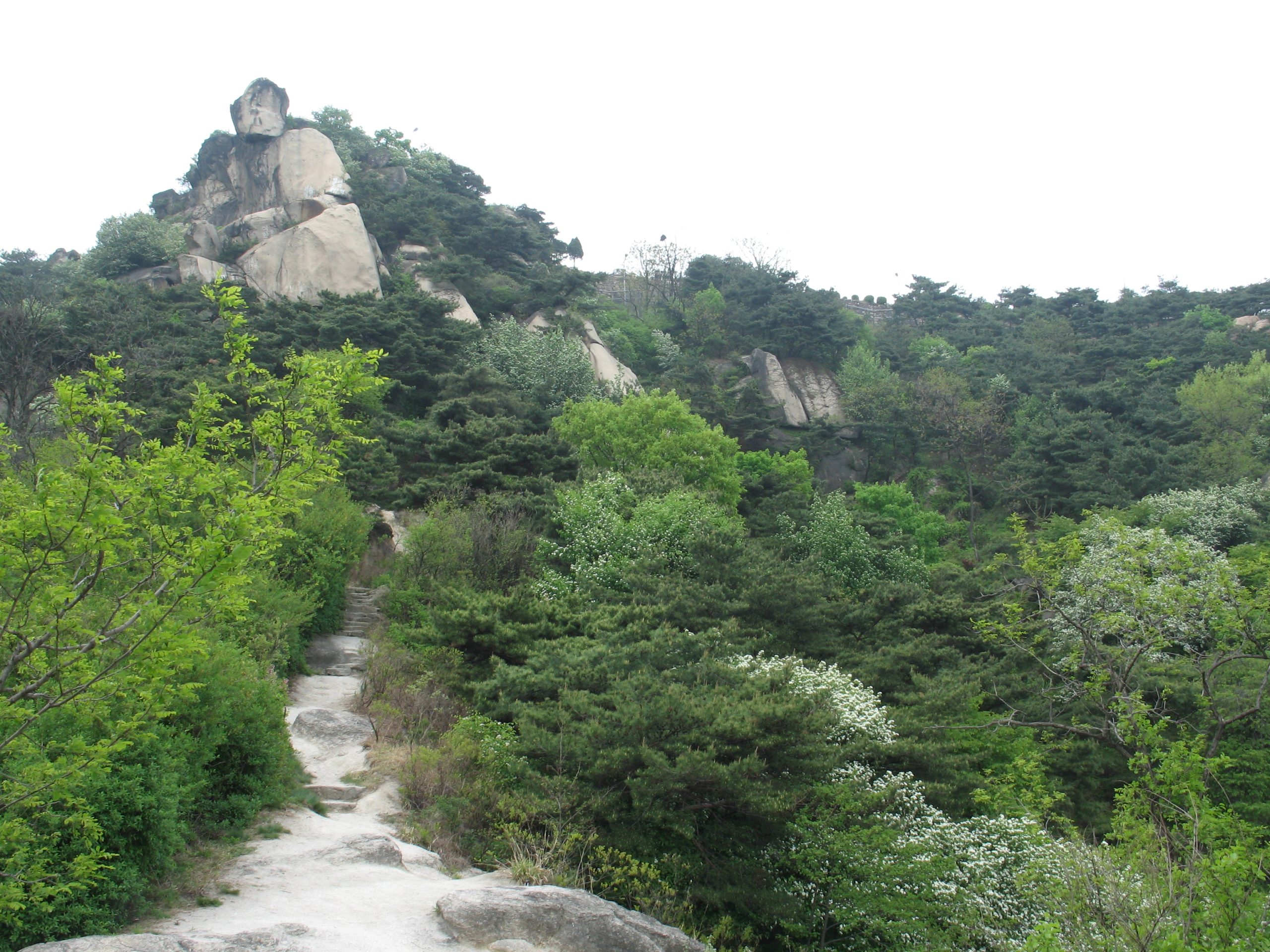
Photo: Korea-Seoul-Inwangsan-01 — Gaël Chardon, CC BY-SA 2.0 via wikimedia (Source: https://commons.wikimedia.org/w/index.php?curid=3996877)
Standing on the summit: what the 338 meters buys you
The payoff is the granite peak. At roughly 338 meters you stand on bare rock with a clean 360-degree sweep of the city. On one side, Gyeongbokgung’s courtyards spread out below. Turn around for N Seoul Tower on Namsan. Beyond it sit the downtown skyline and the green hump of the former Blue House compound. Visitors consistently rank it among the city’s best free viewpoints.
The summit is bare and exposed, which makes the view enormous and the wind real. A layer is worth carrying even on a warm day. The rock can feel slick, so take the final few meters slowly.
What makes the panorama special is the layering. You are not staring at one famous building — you are reading the whole city at once. The old palace grid sits low and tidy near the center, and glass towers climb in clusters beyond it. On a clear day you can trace the ring of mountains that boxes Seoul in. That is the moment the fortress wall underfoot starts to make sense.
Timing changes the experience more than most visitors expect. Arrive between about 7 and 9 a.m. for crisp light, the clearest long-distance visibility, and near-empty rock. Late afternoon trades that clarity for golden warmth and a busier summit. Air quality skews cleaner after rain and through autumn, so a post-shower morning in October tends to give the sharpest skyline.
Following the Hanyangdoseong wall up the ridge
Most of the route hugs the Seoul City Wall, the Hanyangdoseong fortress that ringed Joseon-era Seoul. The path follows the stonework up the ridge, which makes navigation almost a non-issue. Keep the wall on one side and you are heading the right way.
That wall is also why the hike reads as time travel rather than simple exercise. The line you climb is the one soldiers walked centuries ago, with the modern city stacked up beneath it. Inwangsan was one of the four inner mountains that anchored the original fortress city. The stonework here carries real weight in Seoul’s founding story. Some stretches are restored, others are weathered originals. The texture shifts as you gain height. That keeps the walk engaging in a way a plain trail rarely does.
The grade is forgiving through most of the lower and middle sections. Height comes steadily on stairs and packed track, so it is easy to settle into a rhythm rather than scramble. The genuinely steep stretch waits near the top, so it pays to conserve energy early.
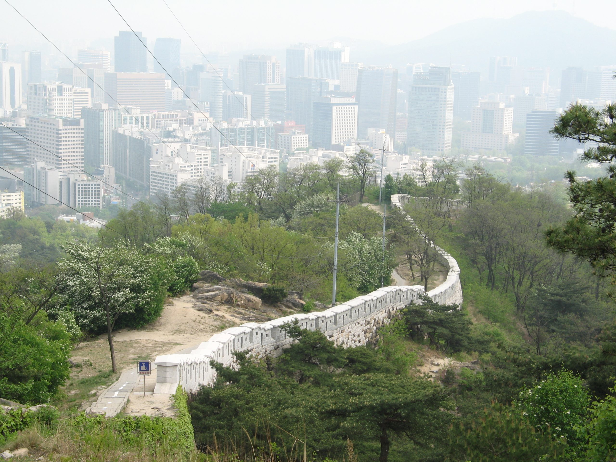
Photo: Korea-Seoul-Inwangsan-12 — Gaël Chardon, CC BY-SA 2.0 via wikimedia (Source: https://commons.wikimedia.org/w/index.php?curid=3997014)
The shrine, the Zen Rocks, and the detour most itineraries miss
Lower on the slope sits Guksadang, an active shamanist shrine relocated here from Namsan. Visitors sometimes encounter an offering or a quiet ritual in progress. It is best treated as a working place of faith, not a photo set.
Just above it stand the Seonbawi, or Zen Rocks — dramatic granite forms said to resemble robed monks in meditation, which have drawn prayer for generations. It is an odd, soulful detour that rushed itineraries tend to skip, and one worth building into the walk.
Terrain, footwear, and a loop that works
By Seoul standards this rates easy to moderate, and it is certainly short. Do not read that as gentle, though, because difficulty is the one thing this hike is consistently under-sold on. Korean hikers who come here regularly still describe it as a proper workout, and the beginners in their groups quite often stop short of the summit. The reason is the staircases. Much of the climb is stone steps built along the wall, and the risers are unusually tall, so each one takes more out of you than an ordinary step. Add the exposed granite slab near the top and the final stretch asks considerably more than the first. Handrails help on the steepest sections. Pace the way up rather than pushing, too — overcook the ascent and the descent on those same high steps becomes the hard part.
For a clean loop, start at Dongnimmun Station. Climb the ridge along the wall to the summit, then descend toward Changuimun gate. That is about 2.5 km one-way and roughly two hours round trip. Sneakers can handle it, but proper footwear pays off, especially when the rock is damp.
One navigation note for first-timers: search the Korean name 인왕산 in Naver Map or KakaoMap rather than Google Maps, whose walking directions are unreliable across most of Korea. The Korean apps route cleanly to the trailheads. On payment: the mountain itself costs nothing. Still, bring a transit card and some small cash. The nearest cafes and convenience stores sit down at the trailheads. Card acceptance at tiny shops around Seochon can also be hit or miss.
At the eastern foot, Suseongdong Valley makes an easy add-on into Seochon, with rock pools and a pavilion. Set expectations before you detour, though: outside the rainy season the water level drops and it can be close to dry, so treat it as a pretty walk rather than somewhere to cool your feet. For a longer day, the Inwangsan Dulle-gil forest perimeter trail loops the lower slopes, and an eco-bridge near Muakjae links Inwangsan to neighboring Ansan. Either way, the descent toward Changuimun drops you near the northern palace district. From there you can continue straight into Gyeongbokgung or the Seochon lanes without backtracking.
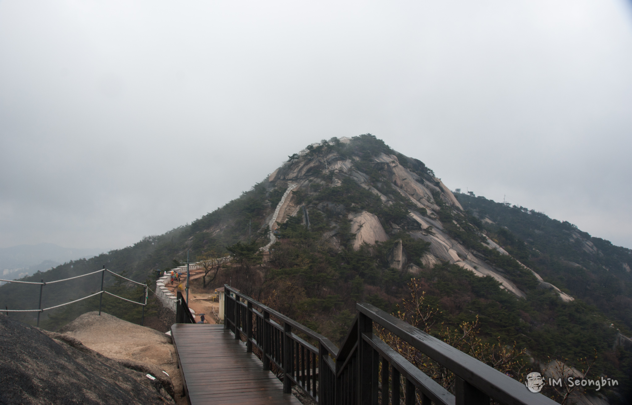
Photo: Geology of South Korea – Inwangsan (인왕산) (8709900822) — Seongbin Im from Seoul, Korea, Republic of, CC BY-SA 2.0 via wikimedia (Source: https://commons.wikimedia.org/w/index.php?curid=76150889)
Inwangsan: the drawbacks nobody mentions
The upper section is steep, exposed granite. Railings help, but it turns genuinely slippery when wet or icy. Skip it after rain or in deep winter unless you are sure-footed.
There are no shops, no vending machines, and no reliable water or restrooms on the trail. Carry your own water and pack out your trash — there is nowhere up top to dispose of it.
Crowds build fast on weekend mid-mornings, and the summit gets a little elbowy at sunset. That has a specific cost beyond atmosphere. Some rock sections are narrow enough for a single line of people, shared by everyone going up and everyone coming down, so a busy day means standing and waiting your turn partway through the climb. There are photo queues as well, at Beombawi — the tiger-shaped rock partway up — and again at the summit marker. The upper rocks have no lighting, so a night descent without a headlamp is a bad idea; anyone staying late should bring a real one. A phone torch does not cut it on that granite, as the people who have tried will tell you.
A further caveat. The nearby former presidential residence and its remaining security facilities mean access can change on short notice. Closures are also possible in extreme weather, and during spring and autumn fire-prevention seasons. Reports also conflict about a Monday “Mountain Rest Day” — some sources say the trail closes, others only the on-mountain facilities — so it is worth verifying before a Monday visit.
Is Inwangsan the right hike for you?
It suits visitors who want the most Seoul-flavored view in town without committing a full day. Casual hikers too, and anyone with a single free evening looking for something memorable. It makes an excellent first Korean mountain, so long as you arrive expecting to work for the view rather than stroll to it.
It is a poor fit if you want zero stairs or feel uneasy on exposed rock. Nor does it suit anyone who cannot manage a moderate climb. There is no shortcut to the summit. Those who would rather wander flat green space can browse our Parks & Nature guides for gentler options around the city.
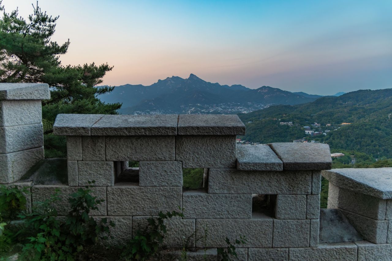
Photo: 인왕산 / Source: Korea Tourism Organization 관광사진갤러리 (KOGL Type 1)
By most measures, Inwangsan is the smartest two hours a first-time visitor can spend above Seoul. Time it for late afternoon or early morning. Pack water and a headlamp. Then let the wall walk you up to the best view in the city. It tends to stay with people long after the trip ends.